


Waterkaarten
Vaar Navigatie
Description de Waterkaarten: Vaar Navigatie
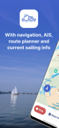
L'application la plus complète pour naviguer sur l'eau en toute sécurité et préparé. Avec navigation, planificateur d'itinéraire, cartes maritimes de 8 pays, connexion AIS, ponts, écluses et ports, informations de navigation actuelles et obstacles. Planifiez les plus belles routes de navigation. Essayez maintenant !
Avec l'application Water Maps (anciennement ANWB Water Maps), vous avez toujours à portée de main tout ce dont vous avez besoin sur l'eau.
Cartes marines, itinéraires de navigation et navigation :
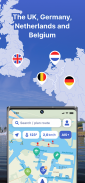
• Cartes marines de 8 pays : cartes marines complètes des Pays-Bas, de la Belgique, de l'Allemagne, de la France, du Royaume-Uni et de l'Irlande, du Danemark et de la Suisse.
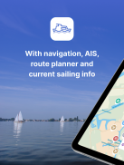
• Navigation en bateau : sachez toujours où vous êtes et où vous allez grâce aux cartes marines embarquées
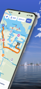
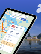
• Planificateur d'itinéraire : planifiez des itinéraires de navigation complets entre votre point de départ et votre destination finale, y compris des itinéraires alternatifs vers et depuis un point sur la carte.
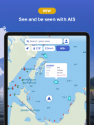
• AIS+ : visualisez d'un seul coup d'œil les navires environnants, y compris leur nom et leur vitesse.
• Lien AIS : connectez votre appareil AIS à l'application et voyez où se trouvent les navires environnants.
• Bientôt disponible : couverture hydrographique étendue - isobathes et profondeurs d'eau le long des côtes d'Europe occidentale
Informations navigation, horaires d'ouverture et fermetures :
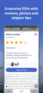
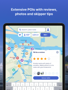
• Informations sur l'almanach : consultez toutes les informations dont vous avez besoin sur l'eau en quelques clics dans l'application
• Cartes des eaux détaillées : Avec plus de 275 000 objets nautiques (ponts, écluses, balisage, places d'amarrage, stations de pompage, restaurants et plus)
• Horaires d'ouverture et coordonnées : ne vous retrouvez plus jamais devant un pont ou un port fermé avec des informations actualisées sur les marinas, les ponts et les écluses.
• Informations actuelles sur le Rijkswaterstaat : restez informé des messages de navigation actuels et des blocages sur les voies navigables.
Avec des cartes de navigation des régions les plus populaires des Pays-Bas, notamment :
• Hollande du Nord : pour les plus belles routes de navigation à Amsterdam, Haarlem, Alkmaar et Loosdrecht, entre autres
• Hollande méridionale et Brabant : découvrez le Biesbosch, Leiden et le Westland
• Frise : bien sûr, les lacs frisonnes ne doivent pas être manqués
• Groningue, Overijssel, l'IJsselmeer… et bien plus encore !
Complet et convivial :
• Service personnalisé : helpdesk 7 jours sur 7 via support@waterkeukens.app
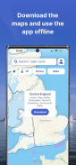
• Utilisation hors ligne : Silence radio sur l'eau ? Aucun problème! Téléchargez les cartes d'eau complètes pour une utilisation hors ligne
• Personnalisation Affichez ou masquez 60 couches d'informations différentes sur la carte nautique pour toujours voir exactement ce dont vous avez besoin
• Mises à jour régulières de l'application : accès gratuit à toutes les nouvelles fonctionnalités avec un crédit
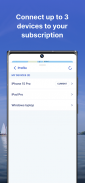
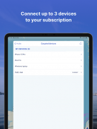
• Utilisation sur 3 appareils : chaque compte utilisateur peut être utilisé sur jusqu'à 3 appareils sans frais supplémentaires.
• Langue : utilisez l'application en néerlandais, anglais ou allemand
• Version Windows gratuite incluse
• Anciennement cartes aquatiques ANWB
Comment ça marche :
L'application Water Maps est gratuite pendant la période d'essai de 7 jours. Vous pourrez alors choisir parmi les crédits suivants :
• Mois (14,99 €)
• Saison (3 mois pour 39,99 €)
• Année (54,99 €)
Le crédit se termine automatiquement.
Remarque : Si vous achetez un crédit pendant l'essai gratuit de 7 jours, nous ajouterons votre nouveau solde à votre crédit restant. Votre crédit acheté n'est pas automatiquement prolongé.
Modes de paiement à crédit :
• Le crédit sera débité de votre compte Google.
• Google vous permet d'utiliser différents modes de paiement, tels que PayPal ou la carte de crédit.
Encore plus de plaisir de naviguer avec un compte Water Maps : vous pouvez créer un compte dans l'application pour activer votre crédit sur un total de 3 appareils.
Attention :
• La taille du fichier du matériel cartographique hors ligne est très importante et il est conseillé de le télécharger sur une connexion WiFi stable.
• L'utilisation prolongée du GPS en arrière-plan peut réduire considérablement la durée de vie de la batterie de votre appareil.
Avez-vous des questions sur l'application ? Contactez notre service d'assistance (support@water Kaarten.app) ou lisez plus sur notre site Web : www.water Kaarten.app.
Attention : cette application est uniquement destinée à faciliter la navigation sur l'eau. Restez attentif à votre environnement pendant la navigation.
Waterkaarten: Vaar Navigatie - Version 11.14.1
(03-07-2025)Waterkaarten: Vaar Navigatie - Information APK
Version APK: 11.14.1Package: nl.anwb.android.anwbwaterkaartenAncienne Version de Waterkaarten: Vaar Navigatie
Autres versions


Applications de même catégorie


